First Alert Forecast: Scattered storms possible Monday & Tuesday in Middle Tennessee
Heat relief arrives mid-week following a historic stretch in Middle Tennessee.
NASHVILLE, Tenn. (WSMV) - Heads up, Middle Tennessee: there are some storms possible early in the week. The good news? This could bring a break from the historic hot weather.
NEXT 24 HOURS:
After a weekend of blistering heat, a much-needed change in our weather pattern is finally underway.
Temperatures will remain hot this afternoon, with highs climbing into the lower to mid-90s. However, increasing clouds and scattered showers and thunderstorms will bring some relief from the heat.
Monday afternoon is a First Alert Weather Day due to the chance for a couple of strong to severe storms mainly South and East of Nashville. Damaging wind gusts will be the main concern, along with locally heavy rainfall and frequent lightning.
Download the WSMV 4 First Alert Weather app for iPhone or Android , so you can stay informed on the go and in between newscasts. We share custom videos, plus you can choose to get messages from us on the latest conditions and forecasts.
TONIGHT’S FORECAST
Scattered showers and thunderstorms will remain possible during the evening hours before gradually tapering off overnight. Mostly cloudy and muggy with lows falling into the upper 60s and lower 70s.
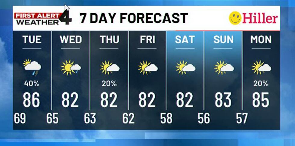
Tuesday
- Morning: Partly to mostly cloudy with temperatures starting in the upper 60s and lower 70s. A few showers are possible.
- Afternoon: Scattered showers and thunderstorms midday as our cold front approaches. Highs will reach the upper 80s to lower 90s. A few stronger storms could produce gusty winds.
- Evening: Scattered showers and storms remain possible, with temperatures falling into the 60s overnight.
Wednesday
- Morning: Partly to mostly cloudy with a few lingering showers possible. Temperatures start in the 60s.
- Afternoon: Much more comfortable with highs in the lower to mid-80s.
- Evening: Partly cloudy and more comfortable with overnight lows falling into the 60s.
Thursday
- Morning: Partly cloudy and comfortable with temperatures in the upper 50s and lower 60s.
- Afternoon: Highs will reach the lower 80s with a chance for a few isolated showers.
- Evening: Partly cloudy and mild with temperatures falling into the 60s.

Friday
- Morning: Partly cloudy and comfortable with temperatures starting in the upper 50s and lower 60s.
- Afternoon: A mix of sun and clouds with highs in the lower 80s. A few showers and storms remain possible.
- Evening: Partly cloudy with a chance for a lingering shower.
THE WEEKEND / LOOKING AHEAD
A fantastic Fall weekend is on the way, with sunny skies and highs in the lower 80s and morning lows in the 50s.