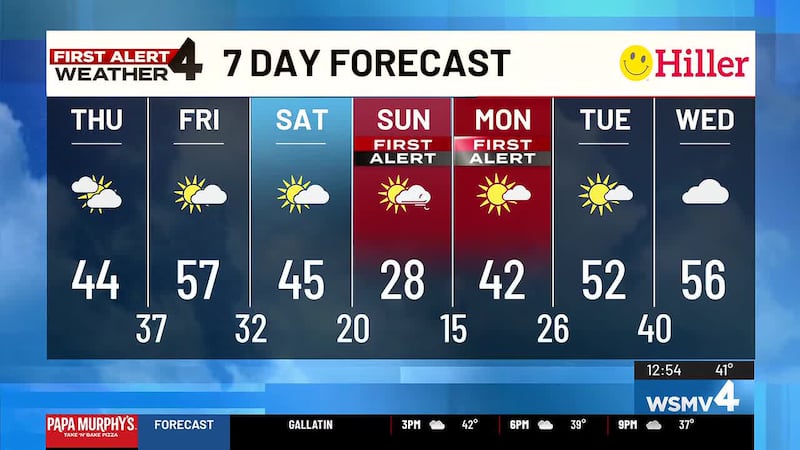
First Alert Weather Day: Strong winds on Monday, Tuesday
Strong, gusty winds of 40mph+ are possible across the Mid State.
NASHVILLE, Tenn. (WSMV) - A WIND ADVISORY goes into effect across the Mid State starting Monday at 1 p.m. until 7 a.m. on Tuesday.
Sustained wind speeds will reach up to 20-30 mph with gusts as high as 40-50 mph being possible at times.
Make sure you secure any loose objects in your yard and wind gusts could cause downed tree limbs and even cause isolated power outages in some areas.
Along with the gusty wind, the very dry air will persist, so there is still an elevated fire danger across the Mid State. Outdoor burning is discouraged.
Download the WSMV 4 First Alert Weather app for iPhone or Android. Our team of meteorologists will send alerts to your phone about conditions headed your way. They also share custom videos about the weather where you live.
Have weather pictures or videos? Share them here.

Most of our day will stay dry until late this evening when showers and storms rumble into the Mid State ahead of a cold front. Those showers and storms will continue through the overnight hours and even though we may see few of these downpours, there is no severe weather threat expected.
More than 1″ of rain is expected across the Mid State. Most of the rain will taper off by Tuesday, but a few scattered showers may pop back up Tuesday afternoon. Highs on Monday will be in the middle and upper 60s while Tuesday’s highs will be in the lower 70s for most.
By Wednesday, the forecast looks dry. The morning will be cool with temperatures in the 40s, but by the afternoon highs will be in the upper 50s and lower 60s.
Thursday is similar temperature-wise, and mostly sunny skies are expected.
On Friday, warmer weather will return with highs back in the 70s thanks to a wind shift to the south.
This weekend is looking nice so far with highs in the upper 70s and a mix of clouds and sunshine.
**** Watch: Step-by-step instructions to program your NOAA Weather Radio. ****

Copyright 2024 WSMV. All rights reserved.